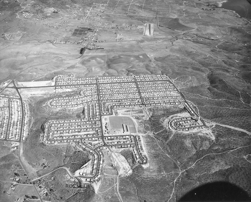
| IT'S
ANOTHER ROZELLE MYSTERY PHOTO. There appears
to be a lake in the upper right corner and
possibly a small landing strip to the left of
that. I'll await your responses.
Couldn't
resist the photo, which seems to be looking
east along San Vicente St in what
maps.google calls Jamacha Lomita. The small
road that enters midway up the left side and
winds on east is Jamacha Rd. Part of the
north shore of Sweetwater Reservoir is just
visible in the upper right. Spring Valley
Shopping Center (per Google) is about where
the landing strip was. The school is still
there, with most of the original buildings,
but Google street level views aren't
detailed enough to show the name. I just
checked the San Diego City Schools website
and quickly found that it is Audubon
Elementary School, 8111 San Vicente St. It's
a K-8, school, which of course is weird to
us who grew up with K-6, 7-9, 10-12. Another
sign that things have gone to hell. -- Bob
Richardson '61
The mystery photo is Lomita Village. The E/W
road in the center of the picture is San
Vicente St. The N/S road is Cardiff St.,
with Jamacha Rd on the left side of the
photo -- Paul
Woolery ‘64
That's the Lomita neighborhood just south of
Jamacha Rd, and north of Skyline Dr. The
lake is Sweetwater Reservoir, and the school
in the middle is Audubon Elementary. I had a
difficult time finding it. I used a 1972
Shell gas station map, and finally spotted
the two looping streets. The neighborhood
hasn't changed much on Google Maps -- Mike
Fry ’60
I think the picture is in the Spring Valley
area looking to the east. The built up area
are the streets south of Jamacha Road, north
of Skyline and west of the present SR125.
The water is Sweetwater Reservoir and the
landing strip is the old "Lamps" field (but
Lamps may have been a bit farther to the
north) -- Stan
Faulwetter '72
I believe the mystery photo is showing
Sweetwater Lake in the upper right corner
with Spring Valley to the left. The tract of
new houses on the bottom of the photo is
Lomita Village. The layout of the streets
match page 1290 in an old Thomas guide. From
what I’ve heard the airstrip was private and
belonged to a pig farmer -- Jim
Martin ’60
My first thought was Sweetwater Reservoir. I
have nothing to back this up! Maybe looking
northward towards Spring Valley from Skyline
area. The horseshoe shaped street at far
lower right of housing tract has a water
tank, but couldn’t find anything on it. Not
many landmarks to go by. I'm probably way
off base, but it's still fun to look at the
pictures. I'm anxious to hear what others
see. There used to be an airstrip in La
Presa (formerly known as La Pressa). It was
evidently opened at some point
between1944-45. La Pressa Airport evidently
closed at some point between 1955-58, as it
was not depicted at all on the September
1958 San Diego Local Aeronautical Chart. By
the time of a 1964 aerial photo, the
northern portion of the former airport
property had been redeveloped with housing,
and the southern portion was
covered with the Spring Valley Shopping
Center. Click HERE
for maps and photos of the airstrip
-- Julie
Eskew Daniel ‘64
|
|
|