|
|
|
 |
|
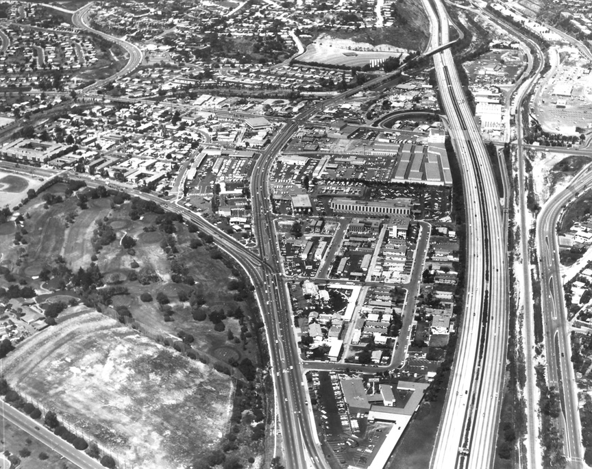
Howard took this photo on April
7, 1980. I know this date well, because I was
in the back seat of the Cessna Cardinal taking
color slides. I recently grabbed a handful of
photos out of the Rozelle bin and was startled
at how closely this shot replicated the one
below. It may answer our question as to
whether the north-south artery below was
Highway 101 or I-5. Notice the growth around
the Pacifica Drive-In at the top, the
completion of Soledad Mountain Rd at the upper
left and the late, lamented Mission Bay
Hospital in the upper middle.
|
|
|
 |
|
THIS IS ROZELLE PHOTO #13463,
which might allow me to research the date.
Howard has written Cove Trailer Park on the
back on the back, and 1980? I know the date
is wrong. My guess is between 1955 and 1965.
I'm going to tell you straight out what
you're looking at, so you can help with the
mystery. The photo looks north from the east
end of Pacific Beach. At the very top you
can see the old Pacific Drive-In. Below that
you can faintly see where Balboa wends its
way west under the freeway, past the Bekins
Van Line storage building and the large
Pacific Telephone building, just before the
intersection with what is today East Mission
Bay Drive. My question to you is -- is that
Highway 5 at the right, or Highway 101. I'm
inclined to go with Highway 5, but the on
and off ramps are a puzzle. I think they
were part of the old Highway 101, but -- in
this photo -- are no longer functioning.
What do you think? (I've come across some
Rozelle negative numbers that lead me to
believe this photo was taken on June 29,
1959)
Top center is the Pacific
Telephone Building where my mother worked
at from 1954 to 1966. To the right of the
Telephone building you will see some
poles, that is where they did telephone
pole climbing and lineman training. Below
the Pacific Telephone building is a
trailer park. And below the trailer park
is the Pacific Telephone garage. Note all
the dark trucks parked in the yard next to
the garage. In the forties and fifties the
telephone trucks were all painted Dark
Green. My guess is the photo was taken
between 1950 and 1955. The road on the
left is old 101, the one on the right is
the 5 -- Terry Hall ‘64
I'm wondering if those
on/off ramps were for the builders to take
their big trucks up on the roadway when
they built I-5. After building the free
way they probably just left them until
something was built on the land next to
I-5. I wish my Dad were still alive as he
worked on that stretch of freeway when it
was being built. I'm sure the photo was
taken before 1977 as we bought a Datsun
pickup truck at Mission Bay Datsun along
Pacific Highway just above the Grand
Avenue split in January 1977.The
dealership isn't in the photo -- Nancy
Watson Wingo, Horace Mann ‘59
In that photo, what makes me think it's
NOT U.S. 101 is that there a no train
tracks to be seen. So the tracks must be
east of the picture. So I'm guessing the
freeway is either I-5 or some earlier
temporary version of it -- Ron Bankhead '63
I’m pretty sure that’s old 101, and it you
look carefully you will see it is one lane
both ways. There is one center stripe of
oil on the roadway and the cars straddle
it. The ramps were closed off because new
ramps were added north and south of the
picture. This didn’t become I-5 until a
few years later -- Steve Petty ‘66
I would say that it is 101. I can see the
off-ramp on the right side right after
Garnet. That looks familiar to me. If it
is really 101, then I would say it was
before 1963. I remember skateboarding on
Interstate 5 when it was being built down
in Little Italy. I think I was about 12,
around 1963. Just guessing on the year.
Interstate 5 went right over where the
Safeway was, so, of course Safeway had to
be demolished. Interstate 5 was 4 lanes on
each side. This picture only shows 2 lanes
on each side -- Guy Casciola ’69
Regardless what it was called when the
photo was shot, the road in question is
where I-5 is now. I learned to surf at Law
Street in 1965 and went down there every
chance I had. I think I would have to go
to Tahiti now to get as excited as I would
rolling into PB In those days. I’m still
working on that time machine albeit
without much luck. Stuck in the present --
Gary L Smith ’70
My vote is for old “101”. The photo shows
a classic “by-pass freeway” built by
CalTrans in the mid-1950s, perhaps just at
the time that the Interstate Highway Act
was enacted. These “by-pass freeways” were
usually just a short segment for that one
mile stretch or so, which would allow
traffic to avoid a busy intersection, and
at the same time, not disturb the existing
commercial areas. Others like it were
built in Buena Park and Camarillo, to name
a few places. It’s interesting to see the
northbound ramps for Balboa were placed
after you crossed over the bridge, and the
southbound on and off ramps at Bunker Hill
Street. Both must have been removed when
the freeway was widened, probably when the
sections through Rose Canyon and along
Mission Bay were built. In the upper left
corner, there is raw dirt remaining from
the WWII housing that had been built
there, and before the current Naval
Housing was constructed -- Earl Feldman ‘61
I think the photo is
closer to 1965, given the look of the few
cars that are identifiable by profile. I
also think it is Highway 101. That is just
how it looked as it passed by the Cudahy
Meat Packing plant a bit further south. I
don’t remember I-5 being only two lanes
each way, but I left the county for a
while around that same time. Where are the
railroad tracks? They should be visible
someplace along that run in the photo! --
Barbara Bright Wilder ‘62
It's 101, otherwise known
as "Murder Alley" because of all the
accidents. There was no "5" then. The
stinky slaughterhouse (Cudahy, I believe)
and slough is out of the photo. I think it
was taken about 1958. The dirt area was
navy housing.. Food City Market is the
light colored building where the road
bends going into PB – Jeannine Berger
Passenheim ’60
 |
 |
|
|
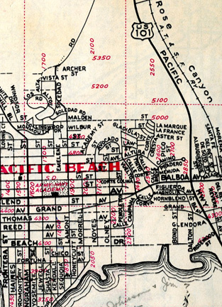
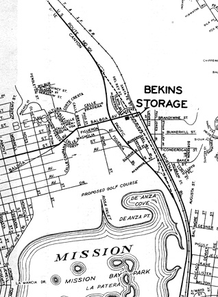
I've thrown in a
couple of maps just to feed the
flames.
I'm guessing 1938 for the map on
the left and 1952 for the one on
the right.
|
|
|
|
|
|
|
|
It may have been both. My
conclusions are at the bottom of this
email. In between, I'll play Sherlock
Holmes. According to Wikipedia, in 1964
California officially truncated the
southern end of the designation "US 101"
at Los Angeles. That may have been where
101 splits from I-5 in downtown LA, or it
may have been where I-405 splits from I-5
in Irvine, the article doesn't say and I
don't remember. But during construction of
I-5 before 1964, the designation
presumably continued intact along 101's
entire historic length below that point,
including where it was sharing long
stretches with I-5. Most of the old route
remains today, under various names. If the
stretch in the photo is a common stretch,
then it could have been US 101, or I-5, or
both, depending on the year. So we need to
know both the year, and whether it was a
common stretch.
Per Wiki-p, the section of I-5 from Torrey
Pines Road to Pacific Highway is shared
with the old US 101; so it was made by
improving 101 rather than replacing it.
But I have a sneaking suspicion (from
other evidence below) that 101 used to be
called P Hwy further north than P Hwy is
now, so it's not clear that Wiki-p knows
exactly what was common. I have attached a
scanned section of a San Diego street map
with a 1993 copyright. On this map, the
north end of Pacific Highway is the south
end of East Mission Bay Drive, well south
of the photo. The north end of P Hwy was
realigned sometime before the 1993 map,
since before I-5 it was a straight shot on
P Hwy past I-8 (the old US-80), P Hwy
there becoming 101 North up to LA, it was
all one road. By 1993, P Hwy's north end
curled around to Sea World Dr where it
became E Mission Bay Dr. On the map, you
can see how the old alignment went: P Hwy
has a separate bridge over I-8 just east
of I-5. Shortly north of that bridge P Hwy
curls west on the map toward Mission Bay,
but a short stub of road extended north.
If you visually extend that stub, you can
imagine it joining onto what by 1993 was
called Morena Blvd, which a second website
[
http://www.westcoastroads.com/california/i-005nb_ca.html
] says was originally 101 "until the
parallel section of Interstate 5 was
constructed in 1967". Aside from the fact
that I am pretty sure that no section of
US 101 was also called Morena Blvd at the
time, the 1967 claim is an odd statement
if, as per Wiki-P, US 101 below LA was
de-comissioned in 1964! To reconcile the
dates, I am guessing that somewhere near
there -- but not necessarily in the photo
-- a stretch of I-5 shared an old 101
alignment along what by 1993 was labeled
Morena, until the new I-5 section was
finished adjacent to it in 1967. A problem
with this photo is that it does not reach
far enough east to see the Morena Blvd
alignment. And a problem with the Morena
alignment further south (on the map) is
that it is so close to I-5, and they both
curve gently right and then left again,
that P Hwy could well have been on that
alignment briefly. Then, continuing
straight where I-5 and Morena curve right,
it would have merged into the I-5
alignment while still south of the photo.
Now I have five clues to offer.
(1) Based on my reading of the map, this
photo looks like it shows the current I-5
alignment, from Glendora St (the east-west
street at the bottom) to the Damon Ave
underpass (street name from Google Maps)
cutting diagonally at the top (Mission Bay
Dr ramps being out of the picture, a
quarter mile north).
(2) But... both north- and southbound, the
picture shows cars running along an old,
bleached-out fast lane complete with an
accumulated central grey stain. No way are
the fast lanes a freshly built interstate!
There are also cars in a very skinny dark
slow lane (fresh asphalt covering part of
a lane-width?). Northbound there is one
car between those two lanes. For a while I
thought that the highway department was
trying to remark and squeeze 3 lanes from
2 older ones, maybe with a little widening
of the right shoulder. Now I'm guessing
that car is just changing lanes, or trying
to avoid the black strip. Most slow lane
drivers may be "hugging the rail" so that
their tires aren't straddling an uneven
edge between the black and light surfaces.
I remember doing that a lot on California
highways in the '60s.
(3) The westcoastroads web pages give
various construction dates between 1962-67
for a few parts of I-5 between north San
Diego and National City. The highway near
Pacific Beach could also have experienced
construction in that time frame.
(4) The photo shows two pairs of curving
structures that look like on/off ramps --
or at least, embankments where ramps may
once have been. One is the east end of
Bunker Hill, one street up from Glendora.
The other goes off the other side of the
highway between Balboa and the Damon
underpass. These ramps are inactive in the
photo (note the absence of freeway signage
overhead). The problem (or the clue) is
that neither of these structures is shown
on the 1993 map. On the map, Bunker Hill
just dead-ends at I-5. The map shows no
street at all coming toward the highway at
the other structure, but it does show
Morena bending away from I-5 just above
Bunker Hill, to cross Balboa on a bridge
east of the map's Balboa interchange with
I-5.
(5) I know the cars are fuzzy when zoomed
in, but I will swear that almost all of
them have the longer flatter trunks and
hoods (relative to cab length) that were
just starting to evolve in 1955, and none
of them appear to have bulky tail fins
that went out of vogue quickly after
Plymouth and Cadillac overdid them in
1957-59. I think that places this photo at
least a few years after the '50s.
So, here's my best guess: This photo is
looking at a stretch of US 101 that was in
the process of becoming I-5. The two ramp
structures would have been orphans from
earlier US 101 access southbound at Bunker
Hill and northbound at Morena Blvd (a
little out of the picture east of the
upper "ramp"). Those structures and the
connection to Morena would have been
removed to reduce the number of access
points to the nascent interstate. The
access ramps from Balboa onto I-5 that are
on the map replaced both earlier accesses.
The Balboa ramps were built after the
photo, and they required rerouting Morena
eastward. Because the old ramps are
inactive, the highway may have qualified
for interstate status and so may have been
designated as I-5 as well as US 101 by
that time. I think the picture was
probably taken around 1963-65. If it was
after 1964, then it was definitely I-5.
Highway department records of when the old
ramps were closed and the Balboa ramps
were built could date it more accurately
-- Larry Orwig, '63
|
|
|
|
|
|
|
|
|