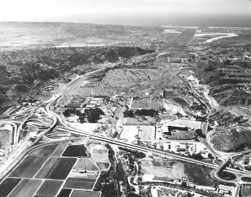
About the 'racing oval' There
was a stable with a training track in that
location (this was in addition to the stable
that used to be where Bloomingdale's is now).
We used to sneak our horses in and use the
backside of the track where no one could see
us -- Sandy Liflander ‘59
I cannot tell you what the “racing oval” is,
but it may have been a workout track for the
horse ranch that used to be where Westgate
Field was built. I took riding lessons at that
ranch and we used to go out in the direction
of that track every week. I don’t remember
ever seeing any cars or anything on it -- Barbara
Bright Wilder ’62
About the "race track" in the aerial photo. As
I recall, there were two stables in Mission
Valley. Kenmore Stable was next door to Town
and Country and one could rent a horse by the
hour and ride "English". The other stable was
further west and one entered from Friars Rd. I
don't remember the name but one could rent a
horse and ride "western" style. I did my
riding at Kenmore so don't know many facts
about the other. Could that "race track" be
something used for horses?? Maybe this will
jog someone's memory -- Lynn Routt Swanson '62
The Polo Grounds were in that area, near
Friar's Rd. I remember riding around a huge
dirt track when it was Kenmore Stables. You
can see the first Kenmore Stables under the
trees south of Westgate Park. Also Valley Lane
Farms northeast of the park. I remember Danny
Daniels stopping our riding lesson to point
out Arthur Godfrey's palomino there -- Katy
McGuire Boswell ‘68
I love these aerial photos.
Note the long-forgotten Westgate Park, home
of the Padres after leaving Navy Field. I
remember seeing a game there called "Donkey"
baseball, which required each player to have
a donkey on the field. They had to drag or
coax their donkey to go with them as they
fielded the ball...Does anyone else recall
this crazy game? The other thing is that you
could stand outside the short fence and
catch homeruns. Also, this is long before
Fashion and Mission Valley centers -- Patrick
Edwards, '67
Are we still playing Guess The Photo? This
one looks west along Mission Valley, with
Cabrillo Freeway toward the bottom. The Town
and Country is brand new and the golf course
is under construction. I have no
recollection of a baseball park where
Fashion Valley is now, but I pretty much
left San Diego in fall of 1961. I don't know
what the racetrack farther west was either
(visible in your "1946" photo as well). I do
remember the delicious flats of tomatoes and
bags of cukes and corn that my folks eagerly
bought from the truck farms in Mission
Valley. Can't get produce like that anymore
-- Bob Richardson '61
I really enjoy these historical photos of
San Diego. The latest shot is obviously the
construction of the 395 / I-8 interchange
(formerly the 6th street extension and US
80). Also prominent is the new Westgate Park
of the Padres (formerly at Lane Field
downtown -- both of which I attended). The
site is now Fashion Valley Mall. The Padres
moved to the Stadium with the Chargers in
1967. Now here is my question. Last week
there was speculation on whether there was a
highway cloverleaf at PCH and US 80 in 1946.
In the 1946 photo you can see there was no
major interchange at 395 so the 1946 photo
is clearly the earlier shot. Yet in the 1958
photo the 101/80 interchange in the distance
appears simple. My opinion: we just can't
see the cloverleaf details from that
distance. I remember in the early ‘50s
taking a test drive in a Hudson with my
parents in Mission Valley. The dealer drove
us around and around a cloverleaf to
demonstrate handling of the car. The
location most certainly had to be the PCH
cloverleaf since the 395 interchange hadn't
been built (as we can see) until 1958. By
the way, highway cloverleafs came long
before Interstate freeway interchanges. The
first one was built in New Jersey in 1929 --
Rodger Gredvig '64
Does anyone know what it is that looks like
an oval racetrack in the old photos from
1946 and 1958? It can be seen in both photos
in Mission Valley just east of Morena and
north of 80. I know there were horse stables
down near there at one time. These are sure
fun!!! Please do more -- Susie Johnson Martin ’71
The 1958 photo is looking west with the
freeway interchange of 395 and 80 in the
foreground, including open space east of 395
and a small amount of development west of
395. I really liked the 1946 aerial photo. I
hope you can send my email address to Bruce
Parker, class of '62, because he probably
lived in the government housing near Juan
Street during the time period that I lived
there. I lived there between 1946 and 1951.
I attended Fremont Elementary School. I
remember John Allison attending Freemont
when I did. I have many interesting memories
from my early years in Old Town. Thank you
John for all your work on this web site over
the years -- Richard Saunders ‘61
|
|
|