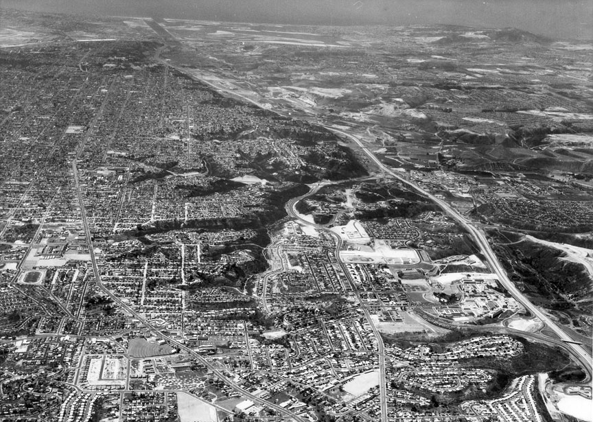
There's
no date on this Howard Rozelle aerial but,
once you get your bearings, you'll be able
to pick up little hints that will help you
figure it out. I'm gonna guess 1955.
I
think the aerial photo is closer to 1960.
The Crawford track is visible on the left
and I'm not sure that would have been
complete in '55. Also, I moved to the
college area in 1961 and in the photo, the
grading and construction of our
subdivision is visible. My dad sold that
tract of houses and I'm pretty sure that
Baja Drive didn't extend from Campanile to
54th St. in '55. Fun though, to spy Horace
Mann and the Campus Drive-In -- Jeff
Lee '66
Great photo! But it can't be 1955 -- the
Crawford football field and track are
already there. I notice the area south of
Manhasset Drive is just being developed
(College Gardens Ct, Stone Ct, south
extension of Hewett Dr). If anyone
remembers when those homes were built,
that'd date the photo. I don't know who
built those homes, but the ones to the
north were built by Crawford dads Drogin
and McCorquodale -- Bob
Richardson '61
You are right. Once I got my bearing with
the photo, it was easier to find things.
My parents lived at the end of Seminole.
Made finding the olde homestead easier.
(to the left of the foreground) The Radio
Station KCBQ Transmitter, and towers were
across the street. KCBQ moved about
1959-60 to Santee. The houses on the west
side of Seminole went up pretty fast. The
Campus Drive-in is intact. Most of the
apartments have not been built in the
area. You can see an L-shaped street just
West of Seminole, but no apartments yet. I
'm thinking that your guess of 1963 is not
too far off. Maybe a bit earlier -- 61-62.
I first got married and moved away in the
fall of '63 -- Pat Chambers ‘60
The Rozelle picture appears to be 1961. I
grew up on College Gardens Ct which is
under construction in the white spot
almost dead center of the photograph,
north of Montezuma Rd., west of San Diego
State and a little east of Alvarado
Estates. There appears that only one house
on our street had been built, and our
house is not yet up, but ours was built in
'61 and my family moved in in '62 . . . so
that's why I'd peg the date at '61 -- Keep
up the good Colt work! -- Steve
Taylor ’76
I think '55 is too soon for this one - you
can see the Crawford football field in it
and that would not have been there in '55
as the school didn't open until the fall
of '57. On the other hand, I think it's
earlier than '63. My house was at the
corner of 54th and Collier, which I'm
pretty sure I've identified in the photo.
The road cut for 54th from Collier through
to Montezuma shows in the photo and I
don't think that was done yet in '55
either. It started out as a cut for water
and sewer mains and wasn't made into a
paved road until later. My memory is that
by '63 houses were beginning to be built
in the canyon below my house and there's
no evidence of that construction in the
photo, and the house construction closer
to the Montezuma end looks to be just
beginning. It started at least a year or
two before the houses were built at my
end. By the time I graduated from SDSC in
'64, the whole canyon was pretty much full
of houses. It doesn't look like
Collingwood Blvd is built yet, either. I'd
guess the photo was from '59 - '60.
Looking at Mission valley, it doesn't look
like Westgate Park is there yet, either,
although that would be pretty small in the
photo and maybe its just too small to see
-- Clyde
Tyndale '60
I enjoy your photo quizzes, but coming up
with dates is difficult. In this photo, I
can use my limited athletic career to date
two fields. On the left side of the photo
is the Crawford High track, just east of
Horace Mann. That makes it post 1957, but
the field looks well established, so it is
a few years old. I also see the new SDSC
track along with Petersen Gym, just north
of Montezuma Rd. I attended SDSC (SDSU
came later) from 1960-65, and my first PE
classes were at the new gym, so it is
around 1960. There is lots of new
construction going on all over the college
area, but how to date them? I could see
that a small subdivision is being built on
the other side of Hardy Elementary School.
A modern street map tells me it is College
Garden Ct. I Googled that street, and
found a house for sale. The real estate
details claim a 1962 construction date.
That's my guess for the photo. Did you
notice the old landing strip in Alvarado
Estates? I remember it from back then. The
same man that built the airstrip also dug
a bunch of caves above Montezuma Rd.
Another family had their own cave system
in Kensington -- Mike
Fry ’60
Pretty good guess on that photo. It was in
the 1950s somewhere. I can tell because
Henry Clay Elementary School (down at the
extreme bottom of the picture) was still a
school/playground at the time, not the
park it's been for the past 40 or so
years. I lived just south of the
school/park. Clay was built around 1956. I
never went there (I finished my term at
John Muir), but my brother went to Clay
for two years – Ron
(no last name and I erased the email
before I could get the email address and
figure out who it was)