|
|
|
 |
|
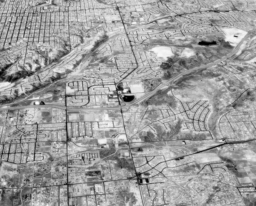
I'm
not sure why Howard used a yellow filter on
this aerial, but it turned asphalt streets
really black and foliage eerie white. On the
other hand it made it easier to figure out
where you are, or would have if Howard
hadn't provided two false clues on the back.
He wrote "Mission Valley", which is not
visible, and "Alverado Drive-In", which is
misspelled -- and not the theater in the
middle of the photo. Having said that, your
house is probably in the photo, if you lived
south of El Cajon Blvd. Too bad it's too
small to see.
It is always fun to see the
aerial photos and try to figure them out.
This one had me baffled until I realized
that indeed, it was Chollas Lake
(confirmed by the radio towers). And to
think – we didn’t even know Chollas Lake
existed in the old days, but there it is!!
I don’t remember what the drive-in was -- Barbara Bright Wilder ‘62
The drive-in theater in the Howard Rozelle
photo is the Rancho Drive-In at Euclid and
94. As Euclid heads north it jogs to the
right and becomes 54th Street. Chollas
Lake is near the upper right corner. The
white area at upper right corner (east of
lake) is where College Grove Shopping
Center was built. If you look very, very
closely in the space above Chollas Lake
you can just make out the three Navy radio
towers that used to be there. To the
northwest of Rancho Drive-In are the hills
and valleys running along Home Avenue. I
sure enjoy these photos and am glad you
found them -- Julie Eskew
Daniel ‘64
Great picture and I recognized the area
immediately. The drive-in theater in the
center was the Rancho drive-in. Hwy 94 is
south of it. The other dark area to the
northeast is the Chollas Reservoir. It
appears that College Grove was being built
at the time -- Susan Cone Milow ’68
This photo looks north showing El
Cajon Blvd and 54th top center. More
important to me, it shows the future site
of Fedco, just north of the drive-in
(Rancho Drive-In, per Rozelle #16).
Actually, Fedco seems to be there in this
photo (not in #16 though). One of the big
early thrills in my life was setting up a
darkroom in the 10th grade. My enlarger (a
Durst 606) was bought at Fedco,
special-order. I still have all my old
B&W negatives, except for the ones I
took for the Pacer and Centaur. Even
though they were shot with my camera and
my film, I felt compelled (or maybe WAS
compelled) to leave them with Mr. Morphew
when I graduated. I presume they're not in
some Crawford archive. now--more likely in
a landfill. As for the Rozelle photo, it
looks to me like it was shot on infra-red
film. A yellow filter on ordinary
panchromatic film wouldn't do much to
foliage or asphalt -- Bob Richardson '61
The former Rancho Drive-in movie
theater is in the center of the photo. I
could make out three neighborhoods where I
used to live, and two more are just out of
view. It looks like Crawford High School
was completed when this photo was taken.
The parking lots are visible, but Howard's
filter doesn't show the buildings. In the
upper left corner are the 3 towers at the
Chollas Radio Station. They were 640 feet
tall, and they were built in 1914. When
the towers were torn down in the early
1990s, the newspaper article said that the
first report of Pearl Harbor went out to
the fleet from Chollas. The big radio
station on Hawaii was shut down for
maintenance that Sunday morning in 1941
(one of the many reasons the Japanese
chose that time). I design power
amplifiers for a living, and one of my
amplifiers was the last to transmit from
those towers. Our customer had arranged
for a demonstration that my solid-state
amplifiers could replace vacuum tube
transmitters, and Chollas was available. I
didn't know that the towers were coming
down, or I would have gone out for a last
visit. There are dozens of my amplifiers
in use around the world now -- Mike Fry ‘60
This aerial shot has north at the
top. Lincoln High is just above the bottom
left of center. The exact center of the
photo is the Rancho Drive-In, where Cox
Communications is now located. State Route
94 runs east and west just under the
Rancho. The body of water in the northeast
quadrant is Chollas Lake. My house is 6
blocks west of the drive-in, at the NE
corner of 48th & Federal Blvd. Just
north of my house is Webster Elementary,
where I attended K and 6th grades, and
just south of the freeway from there is
Gompers Jr. Hi., where I spent 3 more
formative years. Going up 54th St. you can
see Oak Park Elementary and Holy Spirit
Church & School, where I spent from
1st thru 5th grades. Lutheran High is now
located on that campus. St. Rita's Church
& School is where Euclid, Imperial,
and Churchward streets merge, a mile south
of the drive-in. I think this photo
predates Coca Cola Bottling Plant, but the
"marble orchards" (cemeteries) are there
in the southwest quadrant -- George Fish Jr. 71
|
|
|
|
|
|
|
|